We were pleasantly surprised by the good results, so that we will soon also use the FARO Focus laser scanner for measurements where good local accuracy is required.
Measurements
Two adjacent planes carefully scanned with FARO ScanArm (measuring arm with LLP). From this, a NOMINAL surface is generated (=reference mesh).
With the Terrestrial Laser Scanner (TLS) at distances of 5 m, 9.5 m and 17.5 m the two planes also scanned.
Alignment:
Best-fit of each TLS point cloud to the reference mesh.
Evaluation:
The measurements of each TLS viewpoint are considered individually.
The TLS data are first processed with Faro Scene (no filtering, only cutting out the measured object from the total point cloud).
Import of the fls scan data files into Polyworks software (as a point cloud) and subsequent alignment of each point cloud per best-fit to the reference mesh.
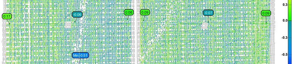
- Calculation of a comparison of TLS point cloud to reference polygon mesh and generation of a colour comparison.
- Calculation of cross-sections through the generated colour comparisons.
Conclusion:
An expected increase in the deviations with an increase in the measurement distance could not be determined (@distances 5 m, 9,5 m and 17,5 m).
A plane can be determined in the range of ±0.5 mm.